The Evolution of Manukau Ranges: A Planners Journey in Cities Skylines 2
1.0 Introduction and Review Mandate
The development of Manukau Ranges presents a compelling case study in the disciplined application of transit-oriented development principles, from initial foundation to a mature, polycentric city of 200,000 residents. This strategic review provides a comprehensive analysis of the key urban planning decisions, infrastructure strategies, and economic policies implemented throughout the city’s evolution.
The scope of this review is a chronological evaluation of the city’s distinct development phases. It begins with the foundational establishment of core infrastructure and initial residential and industrial zones. The analysis then proceeds to the ambitious formation of a high-density, mixed-use City Centre, followed by strategic industrial and agricultural expansions designed to secure the city’s resource base. Finally, the review examines advanced infrastructure retrofitting and urban renewal projects undertaken as the city reached maturity.
This analysis culminates in a cross-cutting assessment of the overall effectiveness of the planning methodology employed. By examining both successes and challenges across the city’s lifecycle, this document aims to distil the core principles that have shaped Manukau Ranges and provide forward-looking recommendations for its continued development.
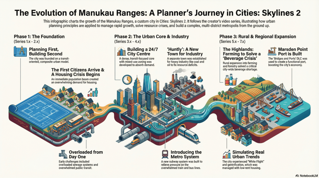
2.0 Foundational Planning and Initial Growth (Series 1.x – 2.x)
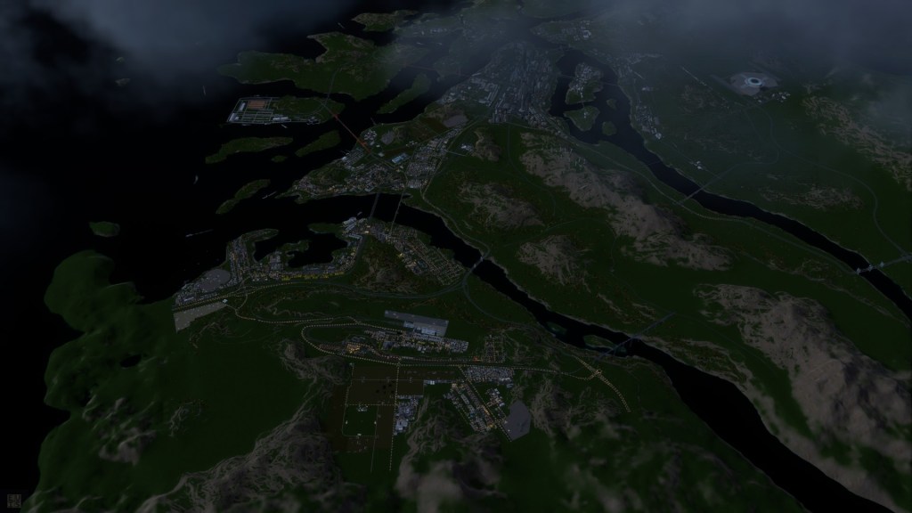
The founding of a new city is a critical phase where initial infrastructure and zoning choices establish a development path that influences its long-term trajectory and spatial form. The foundational planning for Manukau Ranges was guided by a “composite urban model” centred on transit-oriented development, a principle that aimed to prioritize efficient public transport and shape a dense, accessible urban fabric from the outset.
The initial layout of road, rail, and port infrastructure was strategically implemented to support this guiding principle. These choices demonstrated a long-term strategic coherence, establishing a framework that would later be realized in the sophisticated, multi-modal transit systems of the urban core. However, the immediate influx of residents and businesses placed significant strain on foundational utility systems, testing the city’s reactive capacity.
Initial Infrastructure Deployment Assessment
The table below evaluates the initial effectiveness of key infrastructure components during the city’s establishment.
| Infrastructure Component | Initial Effectiveness and Outcome |
| Sewer System | Immediately overloaded upon the arrival of the first residents, necessitating the deployment of a full-scale water treatment plant significantly earlier than projected. |
| Power Grid | A geothermal plant, supplemented by wind turbines and batteries, provided a stable initial power supply, demonstrating a commitment to non-fossil fuel energy sources from the beginning. |
| Water Supply | An initial system of water pumps and towers was established. While functional, it required careful management and expansion as the population grew rapidly. |
| Initial Transport Links | The early establishment of road, heavy rail, and port connections was successful in attracting residents and industry, forming the backbone of the city’s transit-oriented model. |
The city’s administration responded to the immediate and high demand for residential and industrial zones by implementing accelerated intensification and expansion strategies. In districts like Worry Town and Kai Valley, initial medium-density zones were rapidly up zoned to high-density to accommodate the population surge. This agile response, while necessary, further underscored the challenge of ensuring that utility infrastructure could keep pace with exponential growth.
This foundational phase was characterized by a successful, transit-focused spatial plan that attracted rapid growth, but it also revealed critical vulnerabilities in utility capacity that required immediate and decisive intervention.
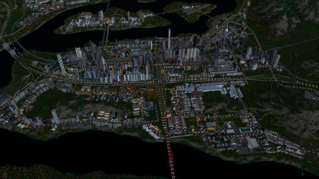
3.0 The City Centre: A People-Centric, 24/7 Economy (Series 3.x)
Following the initial growth phase, a strategic decision was made to develop the City Centre, Manukau Way, and Manukau Riverside as a high-density, mixed-use urban core. The stated goal was to deliberately avoid the 9-to-5, car-centric model that “plagues… city centres not only in New Zealand but also more commonly in North America as well.” Instead, the plan sought alignment with the more successful international model of a vibrant, 24/7 economy found in the city centres of Europe, Asia, and Australia, achieved by co-locating commercial, office, high-density residential, and entertainment functions to ensure the area remained active around the clock.
The transportation strategy was the physical manifestation of the city’s founding transit-oriented principles. The core was designed around a multi-modal transit hub integrating a dedicated transit mall for buses, taxis, and trams with major heavy rail and metro stations. This infrastructure was designed to make public transport the most efficient and logical choice for moving into and through the city’s core, minimizing reliance on private vehicles and prioritizing pedestrian accessibility.
The zoning strategy for the City Centre was meticulously planned to achieve the desired urban form and economic vitality.
- Architectural Division: The area was deliberately split into two distinct high-density architectural styles. One side of the motorway features North American and North-eastern US styles, while the other side utilizes Chinese styles, creating visual diversity within a dense urban fabric.
- Mixed-Use Integration: Zoning intentionally blended high-density residential towers with commercial, office, and hospitality spaces to create a complete urban neighbourhood.
- Entertainment District: The Manukau Riverside area was specifically zoned as an entertainment hub, concentrating leisure venues to create a regional destination.
To further establish the City Centre’s identity and economic gravity, “signature buildings” and specialized leisure venues like the sports complex and arena were used as strategic “anchor points.” These large-scale projects were intended to attract residents, businesses, and tourism, creating landmarks that define the city’s skyline and serve as focal points for economic and social activity.
The ambitious plan for the City Centre established a clear vision for a dynamic urban core, but its success depended entirely on the city’s ability to support its immense resource and population demands through further strategic expansion.
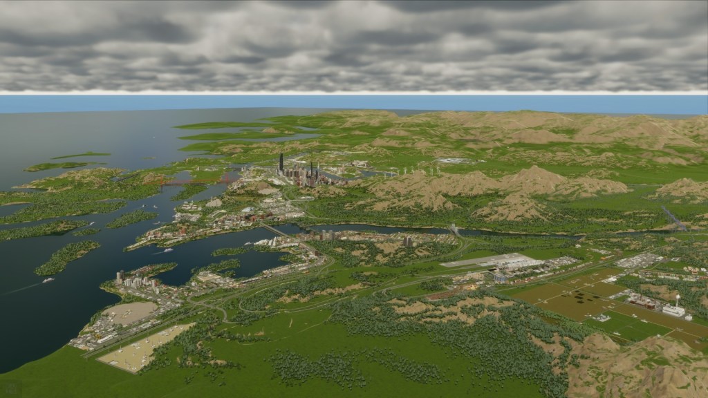
4.0 Strategic Expansion and Economic Diversification (Series 4.x – 5.x)
The resource-intensive “24/7 economy” of the City Centre was only made viable through the concurrent, deliberate externalization of heavy industry and agriculture into dedicated satellite districts. The rapid development of the urban core created significant resource deficits and industrial land shortages, prompting a targeted strategy of developing specialized districts to build a more self-sufficient economic base.
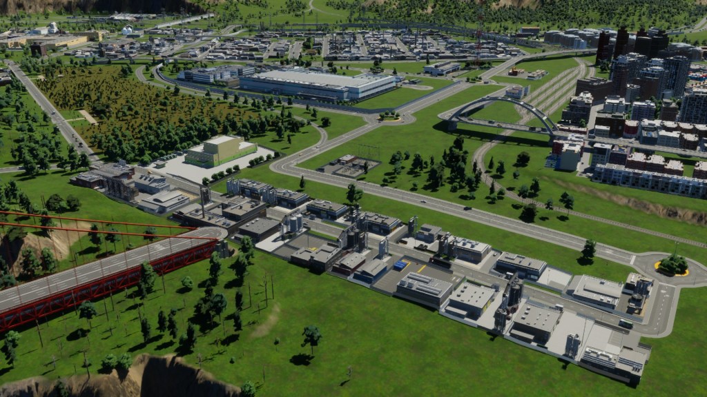
4.1 Industrial Expansion: The Huntly Mining Town
To resolve critical shortages in oil and coal and to provide much-needed land for heavy industry and factories, the town of Huntly was established as a dedicated mining and industrial hub. This decision effectively externalized the city’s most intensive industrial activities, preserving the core for commercial and residential development while securing a local supply of essential resources.
The successful integration of Huntly depended on a critical piece of transport infrastructure: a dedicated heavy rail line. This line served the dual purpose of transporting workers from the main residential areas to the industrial jobs in Huntly and efficiently moving raw materials and finished goods back to the city’s port and commercial centres.
4.2 Agricultural Development: The Manukau Highlands
Concurrent with industrial expansion, the city faced shortages in agricultural products. To resolve this, the fertile plains of the Manukau Highlands were developed for farming and forestry. This strategic move was highly successful in achieving agricultural self-sufficiency and diversifying the city’s economic production, reducing its reliance on imports for essential food and material goods like timber.
To support these new rural communities, essential supporting infrastructure was established, including bus services connecting the Highlands to the main city, as well as the extension of core utilities. This ensured that the rural population remained integrated with the broader urban system while fulfilling its specialized economic function.
These targeted expansions into Huntly and the Manukau Highlands successfully created a more resilient and self-sufficient urban system, but also introduced the new challenge of managing a larger and more geographically complex city.
5.0 Advanced Development in a Mature City (Series 6.x – 7.x)
As Manukau Ranges grew into a mature city, it faced a new set of complex challenges and opportunities, including the need for urban renewal and the development of highly specialized districts. The projects undertaken on Solarian Island and at Marsden Point are indicative of this advanced stage of urban development, requiring sophisticated planning and large-scale infrastructure investment.
5.1 Solarian Island: A Specialized Government District
The development of Solarian Island as a specialized district represents a strategic decision to co-locate key civic and institutional functions. The island was designated as the home for major government facilities, such as the central bank and district hall, as well as the city’s primary medical campus. This approach consolidated essential public services into a single, secure, and prestigious location, separating them from the high-density commercial activity of the primary City Centre.
Ensuring the island’s seamless integration with the rest of the city was paramount. This was achieved through significant transport investment, including the extension of new heavy rail and subway lines connecting Solarian Island directly to the mainland’s transit network.
5.2 Marsden Point: Port Retrofit and Economic Rebalancing
A major infrastructure project of this phase was the retrofitting of a new, modern port at Marsden Point. This undertaking involved complex engineering and planning to integrate a large-scale industrial asset into the existing urban fabric. However, implementation was not without flaws; a significant oversight in procurement resulted in port gates not designed for left-hand traffic, identified as a “huge glaring bug” that serves as a critical lesson in project execution and asset specification.
This phase also coincided with a major economic rebalancing event that triggered significant demographic shifts within the city. The planning response to these changes was critical:
- Demographic Shifts: The administration observed a pattern the source narrator described as “technically white flight and gentrification happening,” where more affluent and socially mobile residents moved from high-density urban areas to the periphery, later followed by a gradual return.
- Housing Demand Spike: These movements resulted in a sustained and significant spike in demand for low-density residential housing, requiring planners to re-evaluate residential zoning and expansion priorities to accommodate this shift in preference.
The complex projects at Solarian Island and Marsden Point highlight the sophisticated challenges of managing a mature city, from large-scale infrastructure renewal to responding to dynamic socio-economic trends.

6.0 Cross-Cutting Analysis and Overall Assessment
Moving from a chronological review, this section provides a thematic analysis of the core strategies that have defined the development of Manukau Ranges. These cross-cutting policies in economics and transportation have been instrumental in guiding the city’s growth and managing its challenges.
6.1 Economic Policy and Crisis Management
The city’s administration has consistently employed direct economic interventions to manage resource crises, steer industrial development, and influence demographic trends. This hands-on approach is evidenced by several key events:
- Beverage Crisis Management: Faced with a critical shortage of beverages, the city implemented targeted tax subsidies for both production and commercial sales. This fiscal stimulus was designed to rapidly boost supply and meet consumer demand.
- Petrochemical Oversupply Response: When faced with an oversupply of petrochemicals, the administration made a deliberate decision not to adjust taxation. This was based on a sophisticated understanding of industrial interdependencies; raising taxes was avoided because petrochemicals also yield chemicals that can easily fall into short supply, risking cascading shortages in other critical sectors.
- Demographic and Workforce Steering: To support the growth of office and industrial sectors, the city used subsidies as a tool to attract “highly educated” individuals. This policy was aimed at ensuring a qualified workforce was available to fill emerging high-skill jobs.
These examples illustrate a consistent planning posture that pairs long-term spatial strategy with agile, short-term fiscal interventions to navigate crises and steer economic outcomes.
6.2 Transportation Network Efficacy
The commitment to a transit-oriented development model has been a defining feature of Manukau Ranges’ planning. The city has successfully implemented a multi-modal transportation strategy that integrates heavy rail, metro, tram, and bus networks. This system has proven highly effective in supporting high-density living in the City Centre, managing congestion, and connecting the central city with disparate industrial zones like Huntly and rural communities in the Highlands. The network’s robust design and extensive reach have been fundamental to achieving the city’s spatial and economic goals.
The Manukau Ranges planning approach is characterized by a proactive, interventionist economic policy and an unwavering strategic focus on a comprehensive, multi-modal public transportation system.
7.0 Conclusion and Strategic Recommendations
This strategic review has analysed the development of Manukau Ranges from its foundation into a mature city of 200,000 residents. The city’s most effective planning decisions have been rooted in a steadfast commitment to a transit-oriented, composite urban model. This is exemplified by the people-centric design of the City Centre and the highly effective integration of its multi-modal transport network. The most significant challenges have consistently arisen from managing the impacts of rapid growth, including overloaded foundational infrastructure, resource shortages requiring strategic expansion, and dynamic socio-economic shifts impacting housing demand.
Based on the analysis of the city’s development, the following strategic recommendations are proposed to guide its future growth:
- Transit-First Future Expansion: Based on the demonstrated success of the City Centre’s integrated transit hub, it is recommended that planned future developments, including the “Bay of Islands” (Series 8.0) and the urban renewal of the City Centre interchange (Series 10.0), be predicated on an identical transit-first principle from their inception. Establishing high-capacity public transport at the outset will pre-emptively mitigate congestion and ensure successful densification, avoiding the challenges of later retrofitting.
- Adaptive Economic and Housing Strategies: Given the observed pattern of demographic shifts and the resulting sustained demand for low-density housing, the administration must develop an adaptive long-term strategy. This plan must balance this housing preference with the city’s core goal of dense, transit-oriented development, potentially by exploring innovative medium-density housing types or creating new, well-serviced satellite communities that do not compromise the integrity of the urban core.
- Targeted Infrastructure Enhancement: Reflecting the city’s polycentric growth and the strategic importance of its specialized districts, future infrastructure investment should prioritize enhanced connectivity. Based on the successes of the existing multi-modal network, the integration of new transport technologies, such as the proposed ferry system, should be advanced to provide a crucial link to Solarian Island and the planned Bay of Islands, reinforcing the city’s transport strength.